From time to time, ISEA will share Great Lakes experiences from guest bloggers. In this blog, volunteer Dave Maynard shares his work in cleaning up groundwater contamination in Boardman Lake. Email marketing@schoolship.org if you would like to submit a Great Lakes experience to be featured.
I have been a volunteer with the Inland Seas Education Association for the past four years. While attending Grand Valley State I spent many days aboard the University’s research/educational vessel D.J. Angus conducting limnological assessments of Lake Michigan. Several of the water quality sampling and analysis tools used aboard the D.J. Angus are identical to those used by the Inland Seas program.
My time aboard the D.J. Angus sparked a love of the Great Lakes and being out on the big waters of Lake Michigan. This blog post intends to tell my story of inspiration to pursue a career in the environmental sciences and how the Inland Seas experience can inspire students along the same path. Also to inspire adults to support funding for the preservation and cleanup of the Great Lakes.
After earning a Bachelor of Science, I went to work for the Department of Environmental Quality, now the Department of Environment, Great Lakes, and Energy (EGLE). Currently, I am a Project Manager overseeing the cleanup of contaminated sites. One of my current projects is a site on the shore of Boardman Lake in Traverse City. The contamination is from a time before most environmental regulations were enacted. Liquid waste was discharged into unlined lagoons where it seeped into aquifers below the site. Our goal is to determine the depth, velocity, and concentration of the contamination where it discharges into the lake. Once those parameters are determined, we can design a system for treating the contamination.
Tracking the contamination plume is done by installing several monitoring wells in a grid downgradient of the contamination plume. Water samples are collected from the wells and analyzed for the contaminants being tracked.
Based on the above information, we concluded that there are two contamination plumes (one shallow and one deep) migrating toward the lake. The next step was to determine the location of the groundwater discharges and to facilitate measurement of the contaminants entering the lake.
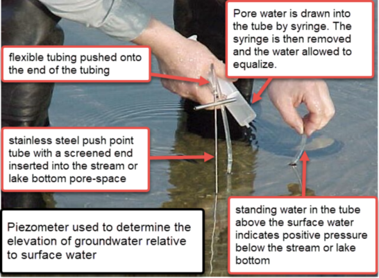
To begin, we estimated that the shallow aquifer was discharging near the shore. A means of determining if groundwater is discharging into a water body at a specific point is to check for a piezometric head. On this project, we used a stainless-steel push-point sampler affixed with clear tubing on the upper end. Pore water (water is that which occupies the interstitial space beneath the sediment bed) is drawn in with a syringe. The syringe is disconnected, and the pore water is allowed to equalize in the tubing. Equalization above the surface water indicates a piezometric head (groundwater is flowing into the lake). On this project, the sampling was conducted by the EGLE’s Geological Services Section (GSS) staff using one of their watercraft as an operational platform.
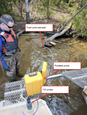
After confirming the piezometric head, water quality parameters (temperature, dissolved oxygen, turbidity, pH, and conductivity) were collected by pumping the pore water through a Yellowstone Scientific Instruments (YSI) cell. A difference between pore water quality data and surface water quality data verified that we were sampling groundwater and not lake water. With our sample points established and their GPS location recorded, we collected pore-water samples that were sent to an environmental laboratory where they were analyzed for contaminants being tracked.
The next challenge was to determine the deep aquifer discharge areas. A technique successfully used by the Geological Services Section at comparable sites was to look for temperature differentials at the lake bottom. In Northern Michigan, groundwater is in the 400 F to 500 F range year-round. Lake water temperatures vary based on factors such as depth, air temperature, and mixing of the water column. If the lake water is either warmer or colder than the groundwater discharge, it will show up on the forward-looking infrared radar (FLIR). For this project, the FLIR is mounted on a drone and flown over the area of interest.
In May 2022 Boardman Lake water temperature was in the 550 F range. Because of the groundwater/lake water differential, we decided to scan the locations where we estimated the deep aquifer discharged into the lake. Unfortunately, the fly-over did not produce clear temperature differential images.
Our backup plan is to conduct another fly-over in the summer of 2022 when the lake water should be warmer than the groundwater. The challenge is that Boardman Lake is an artificial lake created by a downstream dam, as such it is essentially a wide area in the Boardman River. Because the Boardman River is a cold-water stream fed primarily by groundwater discharges in the 40o F to 50o range (36 miles are designated as a cold-water Blue-Ribbon trout stream), water temperatures in the lake may not reach a point where the FLIR infrared radar can read a temperature differential. Stay tuned for an update on how the summer scanning sessions turned out.
*Read the Dave’s follow up post here*
This blog post was written by Dave Maynard. Dave is a Project Manager with the Department of Environment, Great Lakes, and Energy. Dave also volunteers as a crew member aboard the Inland Seas. He works directly in the Great Lakes environment in order to help to preserve and protect our watersheds.